

An atmospheric river, colloquially known as a “Pineapple Express,” persisted in delivering a barrage of rain and snow to California on Thursday, causing road closures and rockslides. This marks the initiation of a two-storm system set to impact the state with bouts of rain, snow, strong winds, and the looming threat of flooding.
The first atmospheric river, currently sweeping through California, has already brought heavy precipitation and disruptions. However, meteorologists are anticipating a potentially more potent second storm to hit the region on Sunday and extend into Monday. Daniel Swain, a climate scientist at the University of California, Los Angeles, expressed concern about the increased risk of widespread and severe flooding and debris flows during the upcoming system.
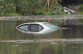
Impacts from these consecutive storms encompass travel disruptions, mudslides, power outages, coastal erosion, and property damage. The initial storm brought 1 to 4 inches of rain to much of Northern California, with the bulk of the precipitation subsiding for San Francisco and Sacramento by Thursday night.
AccuWeather reports suggest that drier air will alleviate rain and mountain snow through Thursday night and Friday. However, residents in Southern California, spanning from Los Angeles to San Diego, may still face travel challenges as the heaviest rain moves inland.
The first storm initiated its assault on Wednesday in the San Francisco Bay Area, progressing southward and reaching Los Angeles on Thursday, creating complications for the morning commute. National Weather Service forecaster Bob Oravec likened the downpour to a “giant firehose,” emphasizing its focus on Southern California. Flash flooding, particularly in urban areas, roads, small streams, and regions with previous burn scars, was anticipated.
The storm, described as a formidable force by some meteorologists, was projected to traverse Southern California on Thursday night before advancing inland over the Southwest from Friday to Saturday. Record-breaking rainfall was reported across the region on Thursday, with Los Angeles Airport setting a new daily record of 2.37 inches.
This atmospheric disturbance, commonly referred to as a Pineapple Express, draws its name from its origin near Hawaii. When these systems make landfall in the western United States and Canada, they bring substantial rainfall and snowfall. In California, a Pineapple Express can unleash several inches of rain in a single day.
As the storm unfolds, winter storm warnings have been issued for the mountains of Southern California and much of the Sierra Nevada. Snow levels in the Sierra Nevada are expected to decrease throughout Thursday and into Friday, resulting in challenging travel conditions over Donner Pass. AccuWeather predicts significant snowfall, with 1-2 feet anticipated in intermediate elevations and passes and up to 4 feet in certain resorts, ridges, and peaks.
Looking ahead, the second storm in the series is anticipated to be more formidable. Climate scientist Daniel Swain warns of its potential for flooding rain, landslides, rockslides, mountain snow, and strong winds. AccuWeather senior meteorologist Day Pydynowski notes that the second storm, originating near Hawaii, may carry a true plume of tropical moisture. Cumulatively, the impacts from both storms are expected to exacerbate travel and flooding issues during the second storm, presenting a more extensive and severe scenario than the first. Residents and authorities alike are bracing for the challenges posed by these consecutive atmospheric river storms in California.